 Important Update: Our application was approved! The new boundary (in reality, multiple trails, areas and parcels) is now approved, and these new sites and areas are part of our heritage area.
Original post: We appreciate the public interest in our pending Boundary Amendment application, which would expand, and nearly double, the size of our state-certified heritage area. Click here for a downloadable map: Four Rivers Boundary Expansion Map
Explore the GIS-Based Map in MEDUSA
Read the Application here: ALTSCHA Boundary Application April 2021.
Watch a recording of the Public Hearing Livestream here:
https://www.youtube.com/watch?v=EHffK7StcYA
Below is the text of the presentation given by our Executive Director, 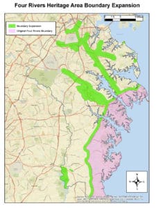
Carol Benson, at the MHAA Public Hearing on Wednesday, March 31.
————————————-
We are delighted to speak to the public today about our organization and its exciting plans for the future, and I’ll start with a big thank you to MHAA, our major funder and partner, and especially to Jen Ruffner, the Administrator of the Program, who has given us much guidance and support over at least 4 years as we have worked through this process. Another big thank you to the Anne Arundel County Cultural Resources Division team (part of the Planning and Zoning Department), whose knowledge and insights have been generously shared throughout, and whose excellent report formed the basis of the proposal we present today. The primary individuals to recognize are Jane Cox, Darian Beverungen, Stacy Poulos, and consultant Jason Vaughan, although there are others who have devoted time and expertise in support ofthis project.
A heartfelt thanks as well to the volunteer members of the ABAP Committee (ALTSCHA Boundary Amendment Project): to Board members Tim Leahy, Linnell Bowen, Barbara Polito, Gertrude Makell, Lily Openshaw, and also to Marcie Taylor-Thoma — a former member of the MHAA Technical Advisory Committee — and to Hope Stewart, a part-time staff member who also works for the City of Annapolis Economic Development Division.
A few preliminaries about fundamentals of the MHAA Program. Our Heritage Area is part of a statewide system of 13 Certified Heritage Areas (CHAs), and you can find a map of them here. As you can see, the program now stretches state-wide, and we, the CHAs, are all quite different.
Heritage Areas are defined by geographic boundaries. If your organization or project is located within these boundaries, and is a nonprofit or a municipality, and you have a heritage tourism project or activity, your organization is eligible for MHAA grants, or a Mini-Grant from the local heritage area.
Being located within a boundary does not mean you are impacted by any restrictions! It does NOT add any later of zoning. It’s like an eligibility layer.
A few words about our organization: ALTSCHA is a nonprofit, “umbrella” organization for heritage partners – museums, historic houses, parks, historic groups, and heritage-related attractions in Anne Arundel County. We are a partnership with the City of Annapolis, Anne Arundel County, the Town of Highland Beach, the State of Maryland, and heritage-related organizations and businesses. We define HERITAGE as historical, cultural, and natural resources. What is HERITAGE TOURISM? It is “Visitation for place-based heritage experiences,” if you will: — Heritage sites seek to authentically represent the stories and people of the past and present.
ALTSCHA was certified as a heritage area in 2001, and this is our organization’s first-ever boundary amendment. We will be celebrating our 20th anniversary in October! As you saw on the map of heritage areas, our area (as defined by our Management Plan and official boundaries) is fairly compact and looks like a long, thick, north-south strip along a portion of the County’s Chesapeake Bay coastline. But Anne Arundel County is a big place. There is more heritage to experience than is contained in our original boundaries. There are significant stories to tell and additional partners that need our tools and services and MHAA’s support. It was a big task that our Board of Directors wanted to undertake — a full county-wide review. We are the first Maryland heritage area to approach it this way, and we honestly didn’t know beforehand how the process would come out, but we are very excited about today’s proposal, which approximately doubles our original area.
More than 5 years ago, I asked knowledgeable experts around the county to share with me the names of sites that were not in the heritage area that are significant. These included Pat Barland, Jane Cox, Janice Hayes-Williams, and members of the Northern Arundel Cultural Preservation Society, such as Betty Mack, Lynda Davis, Lily Caldwell, Tony Spencer, and Yolanda Dickerson. I compiled a list and added it as an Appendix to our Annual Plan submitted with our grant application to MHAA. Some of the locations named were significant in the past but are no longer preserved. Fast-forward to 2018, when this process began. Work was undertaken in 2 phases. First, after ALTSCHA’s Board created criteria and expectations for the work, Anne Arundel County’s Cultural Resources Division (CRD, which is part of the Department of Planning and Zoning), undertook the project of examining relevant places and sites and developing a report of their recommendations for what might be included in a future revised heritage area. Phase 2 was the review and selection by our ABAP Committee.
The CRD team received funding from an MHAA project grant. They were the ideal experts to do these tasks, since they work closely with cultural resources throughout the County. Their detailed process is detailed in their report, and again summarized in our application. Their process was somewhat limited by the COVID-19 crisis, but not significantly impacted. They finished their report in August 2020. The CRD’s Report included a great deal of background information, lists of a wide variety of potential sites, assessments of their management capacity, asset descriptions, and options and choices for our process.
Then began Phase 2, when our Board went to work – we formed our ABAP committee, and we met every two weeks (by zoom) as we reviewed and carefully considered the options. The Committee focused on learning more about each listed site, or asset, where they were located, and their heritage story. As a team, we conferred, went through the lists to see which sites we were familiar with, and one of us at least visited each area or site — and we came back together every two weeks to discuss what we had learned.
As we reconvened meeting after meeting, always relating back to maps of the County, finally a clarity emerged!! The selection of areas just seemed to gel. And surprisingly to us, it was not at all what any of us originally expected – it didn’t fit any preconceived notions, but instead was the result of a completely fresh review. I highly recommend this process to any similar heritage area. For our organization, it’s like “Heritage Area 2.0”! The proposed new areas offer new-to-us, quality experiences featuring recreation, natural resources, a new heritage trail, and attractions in the County that already had existing heritage tourism visitation. Our Chair, Tim Leahy, visited nearly all of the sites himself and created a hand-drawn map that we shared with the County team to develop the GIS-based map we need.
Before we look at maps, a word about terms. What do we mean by a Buffer? Our “buffers” are half-mile strips or areas adjacent to a boundary feature like a trail or a road. What do we mean by a Cluster? This is a fairly small area where we have drawn a boundary line around sites in close proximity to one another.
Now I will use maps to highlight the proposed additions — they belong in 5 categories:
- HALF-MILE BUFFER TO THE EXISTING BOUNDARY
- A NORTH COUNTY AFRICAN AMERICAN TRAIL
- THREE RECREATIONAL TRAILS
- TWO CLUSTERS, a Mid-County Cluster and a Jug Bay Cluster, and
- TWELVE SITES THAT ARE “STANDALONE”, OR CONTIGOUS TO A BUFFER, INCLUDING ANNE ARUNDEL COMMUNITY COLLEGE
Map 1: Click here to download Map 1: HA_Boundary_MAP_Feb2021. This map is a County-wide View – the purple area is our existing boundary, and the green areas are the proposed additions. I’ll take you step by step through the 5 categories.
Click here to download the maps from the presentation: Maps from Four Rivers PPT for BA
Map 2 – Notice in this slide the half-mile buffer, this stretches along the entirety of our present boundary.
Map 3 – In this map detail, I’m showing you a proposed “North County African American Trail,” a route drawn through North County from Pumphrey to Harmans, with a half-mile buffer on each side of the route to include the surrounding communities. North County has changed dramatically in the twentieth century, and much of its heritage has been simply obliterated – by the airport, Fort Meade and NSA, the BW Parkway, the Baltimore Beltway, interstate highway 97, and small-scale residential and commercial infill. For this reason, we propose to highlight seven original North County African American communities with a trail route that starts in the north with Pumphrey, then goes to Furnace Branch, then Freetown, up to Marley Neck, eastwards to Magothy/Pasadena, turning back west to Queenstown, and ending in Harmans/Dorsey to the west. This trail is based on the experience that I and other team members had while driving the route of a copyrighted tour, originally a bus tour, developed by our colleagues from the Northern Arundel Cultural Preservation Society, or NACPS for short. Driving the route of the tour, we could envision a heritage trail to share the stories and help preserve some vestiges of these African American communities of North County. Future interpretation could include a tour, interpretive panels, possibly murals, heritage events, and more. Again, this trail includes a half-mile buffer on each side of the route.
Map 4 – We are also adding recreational trails – most notable these two wonderful rail trails – the fully-developed B&A Trail, one of the gems of our county’s recreational trail system, and the South Shore Trail, partially built with additional sections in development. We include a half-mile buffer on each side of the trails to encompass the many assets remaining from the fascinating railroad-related heritage that developed along these routes. The South Shore Trail terminates in the north in the vibrant historic district of Odenton. We are also adding a portion of the BWI trail, not related to railroad heritage, as a recreational link between sites.
Map 5 – Rail Trails ARE an Ideal Match! Heritage and Recreation are merged into an outstanding experience as you travel along the route. I show you an old map of the county, marking the B&A Railroad line, on the right. As we all learned during COVID, more users are seeking out these outdoor, recreational experiences than ever before.
Map 6 – In this Map Detail, I am showing you one of our two Clusters. This is the Mid-County Cluster, with notable natural resources experiences and many acres of preserved land, also with heritage stories to tell – including Bacon Ridge Natural Area, the Crownsville State Hospital and Cemetery, and the Annapolis Waterworks Park. As I mentioned, we are calling this a Cluster because it contains heritage resources located closely together. It is contiguous to a portion of Generals Highway that is part of the South Shore Trail addition to the heritage area.
Map 7, In this next Map Detail, I am showing you our Jug Bay Cluster, noting the six natural resource areas here: north to south, the Patuxent Wetlands Park, the Nature Preserve at Wayson’s Landing, the Glendenning Nature Preserve, Jug Bay Wetlands Sanctuary, Jug Bay Farm Preserve, and a new separate parcel slightly to the east, the Shepherd Property.
Finally, our Boundary Amendment adds 12 sites with existing heritage tourism visitation. These are standalone parcels or parcels that are contiguous to one of the buffers. They are:
- Chesapeake Arts Center
- Kinder Farm Park
- Fort Smallwood Park
- Downs Park
- Hancock’s Resolution
- Goshen Farm
- National Electronics Museum
- National Cryptological Museum
- Whites Hall
- Linthicum Walks
- Annearrundell County Free School Museum, or the Free School
- Anne Arundel Community College
I should note that there are other partner sites with heritage tourism visitation that already fall within the proposed clusters and buffers, including the Kuethe Library, the Benson-Hammond House, the Rising Sun Inn, and more.
Map 8: This Map shows three examples of standalone parcels, these are Fort Smallwood Park, Hancock’s Resolution and Downs Memorial Park on the waterfront in the northeastern part of the County.
One of the defining aspects of the MHAA Program is its emphasis on Interpretive Themes. With this Boundary Amendment, we have greatly augmented the theme of African American Heritage, and we have extended our maritime theme of “Commerce to Recreation” to a land-based version, focused on railroads and trails. Finally, we have added distinctive new natural experiences, some of which will help us share the Native American story of our area. With this Amendment, ALTSCHA will be better able to provide diverse, quality heritage tourism experiences. We also understand from a recent meeting with County officials that our planned efforts will be leveraging new investments in these same areas by Anne Arundel County.
We thank you for your time and ask you to respond favorably to our proposal, as we see so much opportunity to assist additional areas of the County and include them in our programs and promotions going forward. We are excited to approximately double the size of the heritage area, while being just as strategic as we were in the original boundary. There’s a lot to work on together and we can’t wait to get started.
Coming soon, to better represent this expanded boundary, we will undergo a Rebranding Process, starting in July, which is our next fiscal year. Questions? Please contact us at heritage_area@aacounty.org. To learn more about us and what we do, please explore our website at www.chesapeakecrossroads.org.